 Dr. Charles Holloman Map
|
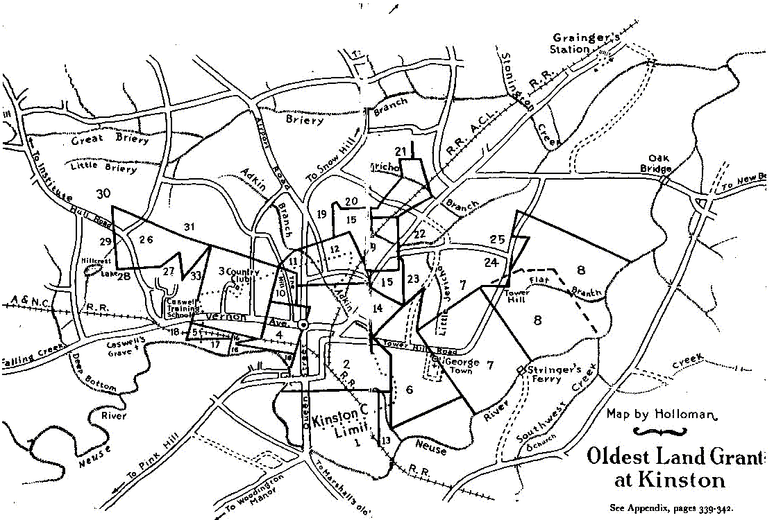
Earliest Land Grants Researched and prepared by Dr. Charles Holloman and used with his gracious permission. Oldest Deed Plats Around Kinston The map on front fly sheets shows original land grants in the Kinston vicinity superimposed upon a map section of Lenoir county. The same is one inch to a mile. Original grants were found in the Land Grant Office, Secretary of State, Annex, Raleigh, NC. This office will be cited below as LGO. In many instances the Land Grant Office has a file envelope containing a report of the original survey with a plat attached. Practically all of the older grants are recorded in two different books in the Land Grant Office. The Kinston grants were plotted first on a map at a scale of four inches to a mile in order to assure higher degree of accuracy and were then transferred to the smaller scale map. It was soon discovered that the very first grants, the two made to Robert Atkins in December 1729, could not be laid off consistent with the metes and bounds as originally stated. The authors attribute this to the lack of intimate knowledge of the area, particularly the course of the Neuse River around the Kinston lands, at the time the grant was made in 1729 and to the fact that these two earliest grants were not placed in the records available to the public until the year 1798. The latter defect appears to have resulted in one later grant being made which over-lapped slightly one of the Atkinsgrants. The adjustment in the metes and bounds of the Atkins grants were discovered by first plotting all other grants surrounding the lands given to Atkins. These surrounding grants make reference to Atkins' metes and bounds and many of them go further and provide well drawn plats which enabled the authors to locate metes and bounds with precision. Each original grant has been assigned a number designation by the authors which number is used on the map to mark the plat referred to in each of the explanatory notes which follow: 1. Granted to Robert Atkins in Bath County, December 16, 1729, and referred to as his "lower survey." In 1798, the grant was found missing from the records. The original was produced by Jesse Cobb of Kinston, the then owner of part of the land and was recorded by order of the General Assembly. See LGO Book 97, p 213. See LGO Book 22, p 202 for which a survey and plat of land tract 13 is in the file. 2. Granted to Robert Atkins in Bath County, December 16, 1729. See further explanation under 1 above. The beginning point of this tract was " Spanish Oak." This oak stood about 480 feet west of Queen Street and 960 feet north of Caswell Street. See LGO Book 97, p 212. See also plat in LGO File Dobbs County No. 1910 to Richard Caswell which is for land tract 16 touching and making reference to this beginning point. 3. Granted to Lazarus Turner, 640 acres in Craven Precinct, June 17, 1736. LGO bk 3, p 346. Recorded also in LGO Bk 9, p 106-7. The western half was deeded by Turner to Michael Rasure (sometimes Rasher), June 29, 1738, for which see Craven County Deed Book 1, p 108, wherein it is also called the half of a tract of land on which Lazarus Turner, the grantor, now lives. 4. Granted to Lazarus Turner for 290 acres in Craven County on November 22, 1738. Described as "beginning at a Spanish Oak Atkinson's corner tree." See LGO Bk. 9, p 367 and also see Craven County file No. 972 which contains the survey and plat. It is found that the eastern end of this grant slightly over-lapped the upper survey of Robert Atkins. 5. Granted to John Rouse in Craven Precinct, March 10, 1736. See LGO Bk. 9, p 235. 6. Granted to Robert Hayes in Craven County, November 20, 1739. Bought by William Herritage from Hayes in 1746. See grantee Index (Old Series) t Lenoir County Courthouse and the will of William Herritage which (sic) left it to his son William Martin Herritage in 1769. 7. Granted to Francis Stringer. An upper grant to Stringer is also labeled 7 LGO Book 9, p 268. Granted dated March 17, 1739. 8. Granted to James Mackilwean for 400 acres, November 17, 1738. LGO Bk.3, p 411-412. This and 300 acres adjacent were sold to Governor Arthur Dobbs by James Mackilwean in 1754 and purchased by the public in 1758 as a site for the capital city. The original grant for the eastern part of the tract has not been identified. On the map the dotted line outlines the 400 acres grant to Mackilwean. The solid line outlines the metes and bounds as laid out in a survey of the whole tract prepared for Richard Caswell who proposed to buy the tract from the State in October 1784. See LGO Bk 62, p 227 and the plat in File No. 1884 of Dobbs County. It is noteworthy that the survey prepared for Caswell in 1784 excludes a small section in the northwestern end of the original Mackilwean grant. This is the section on which the so-called "Herritage House" at Tower Hill stand and suggests that this ancient house did not go with the Tower Hill lands. Adjacent land to the north belonged to Francis Stringer by a grant dated November 18, 1738, for 250 acres. 9. Granted to Job Ives March 1, 1738 10. Granted to Richard Caswell for 85 acres, October 4, 1748. LGO Bk 5, p 345. Sold by Caswell to Robert Compton and later bought again by Caswell who owned it at the time of his death. It then came into possession of his daughter Susanna and her husband John Gatlin. Upon the death of Susanna in 1843 it went into the possession of John C. Washington. A major part of the tract was then conveyed to Jesse W. Grainger and later passed to the Harvey family. Called by Caswell, "The Hill," it was known later as "Washington's Hill" and Grainger Hill." 11. Granted to John Linton for 100 acres, November 26, 1757. LGO Bk 2, p 183, Johnston County File No. 167 for plat. 12. Granted to Thomas Dick for 193 acres, November 9, 1757. LGO Bk. 16, p 157. Also in Bk. 2, p 177. Original survey plat in Johnston county File No. 1160. In 1778 it was owned by Richard Caswell and later by John Washington. 13. Granted to Richard Caswell for 150 acres. LGO Bk. 22, p 202. See plat and survey in Dobbs County File No. 788. Granted dated January 25, 1773. NOTE: The Robert Hayes grant to the east was "supposed" to reach the line of Robert Atkins, lower grant. However, it was found to lack 60 poles doing so and Caswell entered his application for the ungranted section in 1773. 14. Granted to Richard Caswell for 300 acres on January 25, 1773. LGO Bk. 222, p 202. The grant gives valuable information locating the lines of the Robert Atkins grant adjacent and states that the lower Atkins grant land belonged to Jesse Cobb at that date. 15. Granted to Richard Caswell in 1779. Plat in file locates metes and bounds of several adjacent older grants including both the upper and lower grants to Robert Atkins. 16. Granted to Richard Caswell December 28, 1779. See Dobbs County File LGO No. 1910 containing the original survey and plat which refers to the corner of the upper Robert Atkins grant as now (1779) being the line of Herritage (John) and also calls it the Kinston line. John Herritage was given the reversionary interest in the Kinston land and the fee simple in adjacent land by his father William Herritage's will in 1769. 17. Granted to John Rouse, September 20, 1754. L.GO Bk. 15, p 75 18. Referred to as Caswell's patent in the grant above (17) 19. Granted to Thomas Lewis in Johnston County prior to 1759. An adjacent tract to the north was granted to William Williams, March 3, 1759 20. Granted to Captain Simon Bright, son of Colonel Simon Bright, for 200 acres in Johnston County, March 3, 1759. LGO Bk. 15, p 253. The grant records the kinship. 21. Granted to David Ramsey prior to 1773 22. Granted to John Carruthers prior to 1773 23. Granted to Henry Owens for 198 acres in Craven County, November 22, 1738. LGO Bk. 9, p 275 24. William Bond received a grant of 100 acres in this area February 23, 1754. Survey and plat found in Johnston County File No. 86. John Wiggins received a grant of 566 acres in the same general area June 13, 1738. LGO Bk. 97, p 212. Wiggins sold part of the tract to Bond and left part to Thomas Wiggins. The area next to the Tower Hill Land (NE boundary) was a Mackilwean grant. 25. Approximate location of the John Wiggins grant of 566 acres described in LGO Bk. 97, p 212 to which reference in made in 24 above 26. Granted to Richard Caswell, July 21, 1774. LGO Bk. 22, p 345. Five hundred acres. 27. William Bulling's grant prior to the above (26) in which reference is made to it. 28. Belonged to Caswell in 1774. Mentioned in 26 above. 29. Granted to Francis Hill prior to 1774. Mentioned in 26 above. 30. Granted to Richard Caswell, March 21, 1747 31. Belonged to Isaac Tull July 1774. Mentioned in 26 above. NOTE: On November 22, 1746, James Mackilwean applied for a grant which over-lapped a part of his earlier Tower Hill grant. The application was rejected but the survey can be found in Craven County File 1295 of the Land Grant Office. It is noteworthy that a plat of this survey excludes the small area on which the Tower Hill "Herritage House" now stands. This suggests that the house was standing as early as 1746 and probably belonged to Francis Stringer, the adjacent land owner. |